Snail Fossil That Has Completely Transformed Into Opal
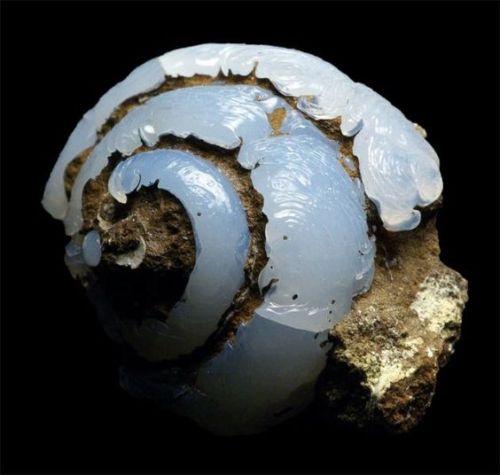
Snail fossil that has completely transformed into Opal
More Posts from Allisoncheri and Others
Celebrating 17 Years of NASA’s ‘Little Earth Satellite That Could’
The satellite was little— the size of a small refrigerator; it was only supposed to last one year and constructed and operated on a shoestring budget — yet it persisted.
After 17 years of operation, more than 1,500 research papers generated and 180,000 images captured, one of NASA’s pathfinder Earth satellites for testing new satellite technologies and concepts comes to an end on March 30, 2017. The Earth Observing-1 (EO-1) satellite will be powered off on that date but will not enter Earth’s atmosphere until 2056.
“The Earth Observing-1 satellite is like The Little Engine That Could,” said Betsy Middleton, project scientist for the satellite at NASA’s Goddard Space Flight Center in Greenbelt, Maryland.
To celebrate the mission, we’re highlighting some of EO-1’s notable contributions to scientific research, spaceflight advancements and society.
Scientists Learn More About Earth in Fine Detail

This animation shifts between an image showing flooding that occurred at the Arkansas and Mississippi rivers on January 12, 2016, captured by ALI and the rivers at normal levels on February 14, 2015 taken by the Operational Land Imager on Landsat 8. Credit: NASA’s Earth Observatory
EO-1 carried the Advanced Land Imager that improved observations of forest cover, crops, coastal waters and small particles in the air known as aerosols. These improvements allowed researchers to identify smaller features on a local scale such as floods and landslides, which were especially useful for disaster support.

On the night of Sept. 6, 2014, EO-1’s Hyperion observed the ongoing eruption at Holuhraun, Iceland as shown in the above image. Partially covered by clouds, this scene shows the extent of the lava flows that had been erupting.
EO-1’s other key instrument Hyperion provided an even greater level of detail in measuring the chemical constituents of Earth’s surface— akin to going from a black and white television of the 1940s to the high-definition color televisions of today. Hyperion’s level of sophistication doesn’t just show that plants are present, but can actually differentiate between corn, sorghum and many other species and ecosystems. Scientists and forest managers used these data, for instance, to explore remote terrain or to take stock of smoke and other chemical constituents during volcanic eruptions, and how they change through time.
Crowdsourced Satellite Images of Disasters

EO-1 was one of the first satellites to capture the scene after the World Trade Center attacks (pictured above) and the flooding in New Orleans after Hurricane Katrina. EO-1 also observed the toxic sludge in western Hungary in October 2010 and a large methane leak in southern California in October 2015. All of these scenes, which EO-1 provided quick, high-quality satellite imagery of the event, were covered in major news outlets. All of these scenes were also captured because of user requests. EO-1 had the capability of being user-driven, meaning the public could submit a request to the team for where they wanted the satellite to gather data along its fixed orbits.

This image shows toxic sludge (red-orange streak) running west from an aluminum oxide plant in western Hungary after a wall broke allowing the sludge to spill from the factory on October 4, 2010. This image was taken by EO-1’s Advanced Land Imager on October 9, 2010. Credit: NASA’s Earth Observatory
Artificial Intelligence Enables More Efficient Satellite Collaboration

This image of volcanic activity on Antarctica’s Mount Erebus on May 7, 2004 was taken by EO-1’s Advanced Land Imager after sensing thermal emissions from the volcano. The satellite gave itself new orders to take another image several hours later. Credit: Earth Observatory
EO-1 was among the first satellites to be programmed with a form of artificial intelligence software, allowing the satellite to make decisions based on the data it collects. For instance, if a scientist commanded EO-1 to take a picture of an erupting volcano, the software could decide to automatically take a follow-up image the next time it passed overhead. The Autonomous Sciencecraft Experiment software was developed by NASA’s Jet Propulsion Laboratory in Pasadena, California, and was uploaded to EO-1 three years after it launched.

This image of Nassau Bahamas was taken by EO-1’s Advanced Land Imager on Oct 8, 2016, shortly after Hurricane Matthew hit. European, Japanese, Canadian, and Italian Space Agency members of the international coalition Committee on Earth Observation Satellites used their respective satellites to take images over the Caribbean islands and the U.S. Southeast coastline during Hurricane Matthew. Images were used to make flood maps in response to requests from disaster management agencies in Haiti, Dominican Republic, St. Martin, Bahamas, and the U.S. Federal Emergency Management Agency.
The artificial intelligence software also allows a group of satellites and ground sensors to communicate and coordinate with one another with no manual prompting. Called a “sensor web”, if a satellite viewed an interesting scene, it could alert other satellites on the network to collect data during their passes over the same area. Together, they more quickly observe and downlink data from the scene than waiting for human orders. NASA’s SensorWeb software reduces the wait time for data from weeks to days or hours, which is especially helpful for emergency responders.
Laying the Foundation for ‘Formation Flying’

This animation shows the Rodeo-Chediski fire on July 7, 2002, that were taken one minute apart by Landsat 7 (burned areas in red) and EO-1 (burned areas in purple). This precision formation flying allowed EO-1 to directly compare the data and performance from its land imager and the Landsat 7 ETM+. EO-1’s most important technology goal was to test ALI for future Landsat satellites, which was accomplished on Landsat 8. Credit: NASA’s Goddard Space Flight Center
EO-1 was a pioneer in precision “formation flying” that kept it orbiting Earth exactly one minute behind the Landsat 7 satellite, already in orbit. Before EO-1, no satellite had flown that close to another satellite in the same orbit. EO-1 used formation flying to do a side-by-side comparison of its onboard ALI with Landsat 7’s operational imager to compare the products from the two imagers. Today, many satellites that measure different characteristics of Earth, including the five satellites in NASA’s A Train, are positioned within seconds to minutes of one another to make observations on the surface near-simultaneously.
For more information on EO-1’s major accomplishments, visit: https://www.nasa.gov/feature/goddard/2017/celebrating-17-years-of-nasa-s-little-earth-satellite-that-could
Make sure to follow us on Tumblr for your regular dose of space: http://nasa.tumblr.com/.
I want to congratulate librarians, not famous for their physical strength or their powerful political connections or their great wealth, who, all over this country, have staunchly resisted anti-democratic bullies who have tried to remove certain books from their shelves, and have refused to reveal to thought police the names of persons who have checked out those titles. So the America I loved still exists, if not in the White House or the Supreme Court or the Senate or the House of Representatives or the media. The America I love still exists at the front desks of our public libraries.
Kurt Vonnegut, I Love You, Madame Librarian (via jennhasablog)
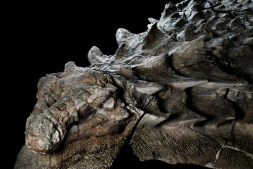
This 110 million-year-old, armored plant-eater is the best preserved fossil of its kind ever found.
From the article:
The more I look at it, the more mind-boggling it becomes. Fossilized remnants of skin still cover the bumpy armor plates dotting the animal’s skull. Its right forefoot lies by its side, its five digits splayed upward. I can count the scales on its sole. Caleb Brown, a postdoctoral researcher at the museum, grins at my astonishment. “We don’t just have a skeleton,” he tells me later. “We have a dinosaur as it would have been.”
Read more on Michael Greshko’s (beautifully written) article at National Geographic. Photos by Robert Clark.


at over four thousand square miles, bolivia’s remote salar de uyuni salt flat is the largest salt flat on the planet. and with a variation in surface elevation of less than a metre, it’s also amongst the flattest land on the planet. but during the raining season, when it becomes covered in a few centimetres of water, the salt flat is transformed into the largest mirror on the planet.
(click for credit x, x, x, x, x)
-
 roz147 liked this · 2 weeks ago
 -
 unnameddoc liked this · 2 weeks ago
 -
 lavieisforme reblogged this · 2 weeks ago
 -
 savyir-genesizz-the-wizard reblogged this · 2 weeks ago
 -
 sleepy-jabberwocky liked this · 2 weeks ago
 -
 capricanis reblogged this · 2 weeks ago
 -
 ittleittle reblogged this · 1 month ago
 -
 faeriecoma liked this · 1 month ago
 -
 unanocheenrio liked this · 1 month ago
 -
 coco-vevo liked this · 1 month ago
 -
 finnstansonly reblogged this · 1 month ago
 -
 holandies reblogged this · 1 month ago
 -
 building-oneself reblogged this · 1 month ago
 -
 ornvmentvl reblogged this · 1 month ago
 -
 watusi-girl reblogged this · 1 month ago
 -
watusi-girl liked this · 1 month ago
-
 veuge reblogged this · 1 month ago
 -
 thesolarsix reblogged this · 1 month ago
 -
 dipdipthechip reblogged this · 1 month ago
 -
dipdipthechip liked this · 1 month ago
-
 saraceaser liked this · 1 month ago
 -
 vivisadventure liked this · 1 month ago
 -
 cubestresser liked this · 1 month ago
 -
 oranges6713 reblogged this · 1 month ago
 -
 remmybeegoosey reblogged this · 1 month ago
 -
remmybeegoosey liked this · 1 month ago
-
 sugarcoated-wishes reblogged this · 1 month ago
 -
 fullmetalbatcow liked this · 1 month ago
 -
 cryptidorange liked this · 1 month ago
 -
 kakushimiko liked this · 1 month ago
 -
 jahloveangel reblogged this · 1 month ago
 -
 r-tsn-ke reblogged this · 1 month ago
 -
 possum-down reblogged this · 1 month ago
 -
 adamtheredbeard reblogged this · 1 month ago
 -
 rozpach liked this · 1 month ago
 -
thesolarsix liked this · 1 month ago
-
 legendsbabe reblogged this · 1 month ago
 -
legendsbabe liked this · 1 month ago
-
 whimsycore reblogged this · 1 month ago
 -
 annie-himym liked this · 1 month ago
 -
 annasinthewalls reblogged this · 1 month ago
 -
 shiftinyou liked this · 1 month ago
 -
 doubleicon reblogged this · 1 month ago
 -
doubleicon liked this · 1 month ago
-
 iitsnotme-123 liked this · 1 month ago
 -
 indig0w0 reblogged this · 1 month ago
 -
indig0w0 liked this · 1 month ago
-
 lonelycatmom reblogged this · 1 month ago
 -
 honeyinc reblogged this · 1 month ago
 -
 jeou liked this · 1 month ago